Trip to Deba
Distance: 4.5km
Duration: 3h until reaching Deba
Difficulty: medium, in some section with slope and mud it is recommended to carry a cane.
Leave Agroturismo Erlete Goikoa and go down to the N-634, and continue 600 metres to the right in the direction of Zumaina. Take the road on the left towards Zumaina.
Leave Agroturismo Erlete Goikoa and go down to the N-634, and continue 600 metres to the right in the direction of Zumaina. Take the road to the left q
After descending 500 metres along an asphalt track, you will come to the Errota Berri restaurant (note that this first 1.1 km can also be done by car, as there is a small car park here). At this point a path begins that leads to the Sakoneta beach (approximately 40 minutes), passing by the Portutxiki viewpoint.
Sakoneta is a rocky cove where you can clearly see all the typical geological formations of the Flysh.
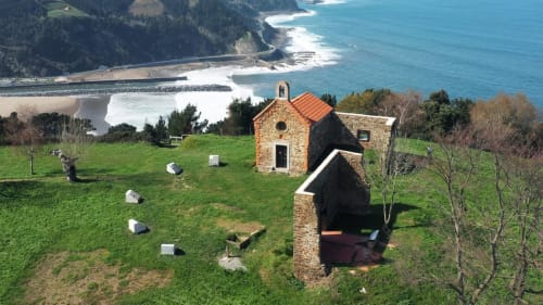
From this point the GR-121 path runs parallel to the Flysh coastline, with spectacular views of the different cliffs (Cape Aitzuri Caves, Andutz Fault, Mendatagina, etc.). After a few stretches going up and down, where we come across several streams accompanied by alders (Alnus Glutinosa), we reach a horizontal stretch that leads us to the wooden footbridge over the N-634 very close to the entrance to Deba, but we follow the path that goes up the hill where the Santa Catalina hermitage is located, and from there we descend and enter Deba, very close to the lifts near the new square.
In summer it is advisable to wear a swimming costume to take a dip in Deba beach, which also has showers to wash off the salt. On this beach you can also go surfing or take surfing lessons.
Trip to Itziar
Distance: 3 km
Duration: 1h until reaching Itziar
Difficulty: low
We leave Agroturismo Erlete Goikoa and go down to the N-634, which we follow 400 metres to the left in the direction of Deba, following the signs for the Way of St. James.
This excursion follows a very horizontal section (there are practically no slopes) of the Way of St. James, passing through shady areas of ash, maple and oak woods and passing next to scattered farmhouses in the municipality of Itziar.
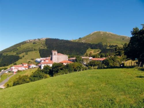
On entering Itziar, the Way of St. James takes us to the church square where we will find stones of different weights used in the typical dragging competitions and gardens with impressive clumps of hydrangeas of different colours.
Trip to Zumaia
Distance: 5 km
Duration: 2h 15min until reaching Zumaia.
Difficulty: medium due to the steep slopes at different points, especially when reaching Zumaia.
We leave Agroturismo Erlete Goikoa and take the road to Santiago in the opposite direction. After 500 metres we come across a small wood, unique in this area, of Virginia tulip trees (Liriodendron tulipifera), follow the signs for the road to Santiago until we reach the junction with the N-634, and take the road towards Elorriaga.
This is an uphill stretch until you reach the village of Elorriaga, where the San Sebastián Chapel stands out. At the exit of the village there is a well-equipped picnic area with a fountain, tables and large shady trees (mulberry, maple and ash trees). On leaving the picnic area, the path splits into two sections that converge at the same place 1 km further on. We recommend taking the section on the left, following the coastline, with spectacular views of the sea and the different meadows.
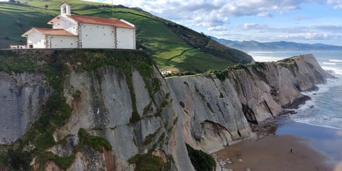
Once you reach Zumaia, the GR-121 descends steeply as you approach Itzurun Beach, before entering Zumaia via Bidea Ardantzabidea.
In summer it is advisable to wear a swimming costume to take a dip in any of the beaches.